
Lakeshore Roads Martin Rd N to Victoria Ave N Improvements - Municipal Class Environmental Assessment Study
Consultation has concluded
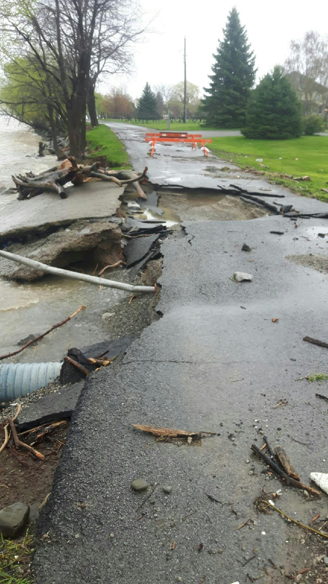
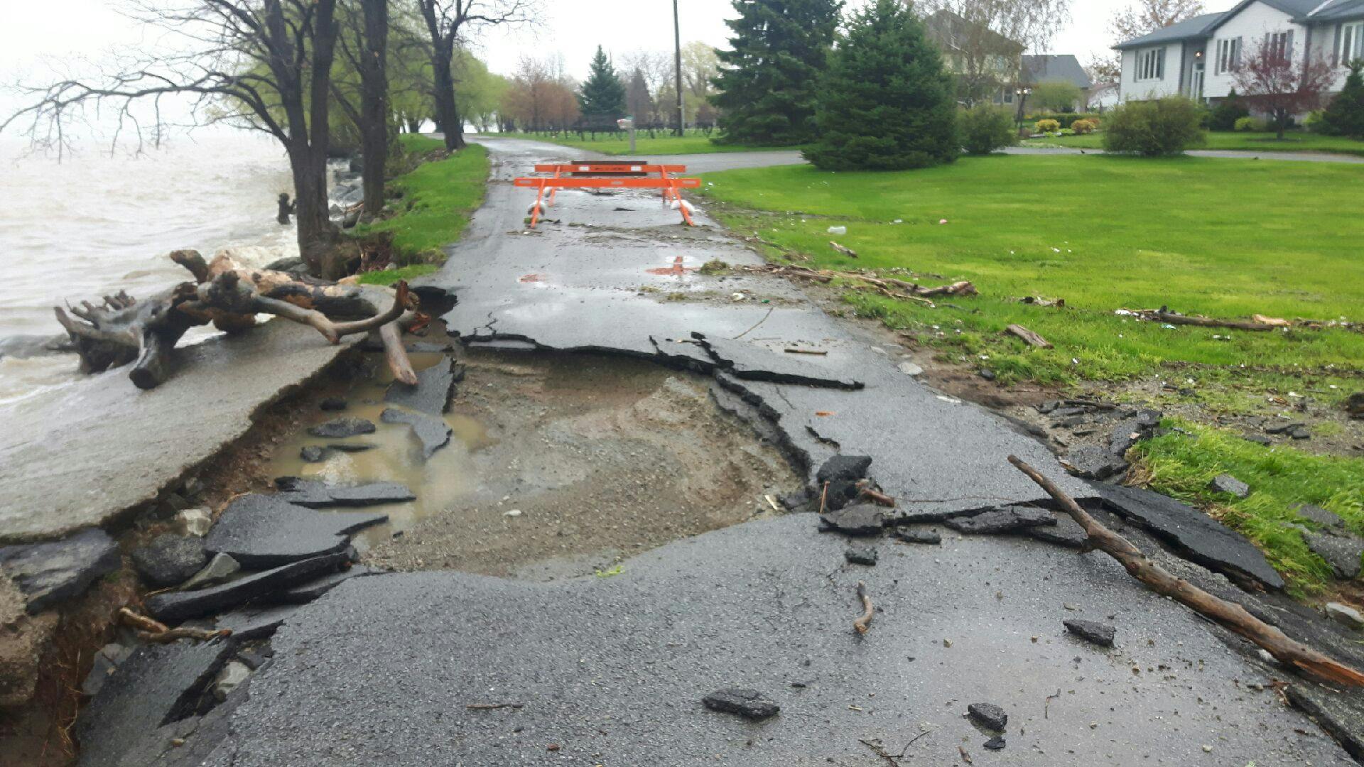
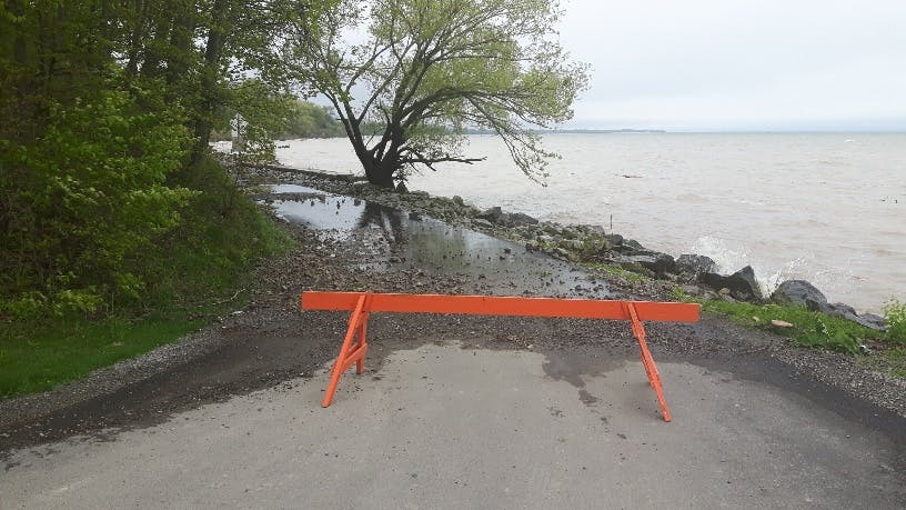
As a result of high-water levels and isolated flooding events during the spring of 2017 and 2019, sections of the Town of Lincoln shoreline have deteriorated. This has resulted in significant damage to the road surface and foundations of Lakeshore Road and Verity Lane.
The residents within the project area were issued voluntary evacuation notices during the 2017 and the 2019 flooding events as emergency services were unable to access these areas during the events. While emergency repairs to the shoreline and road are ongoing, there are still long term improvements and climate adaptation actions required.
This Environmental Assessment (EA) will identify the preferred solution to allow for continued access to properties in the study area. Following the completion of the EA and conceptual design, a project to complete the detailed design will begin.
Project Overview:
This project requires the completion of a Schedule B Class EA to identify a solution that will provide adaptation and resiliency measures so that access to all properties along the lakeshore (between Martin Ave N and Victoria Ave N) is maintained. The Class EA will complete all necessary environmental studies to meet necessary regulations.
Solutions to be considered will include:
- shoreline improvements
- road relocation
All solutions will be evaluated from a technical feasibility, climate adaptation/resiliency, environmental, social and financial perspectives.
During the Class Environmental Assessment, a Public Information Centre (PIC) was held on June 23, 2021 with the impacted residents to provide an overview of the considered solutions and the proposed evaluations. Residents were able to provide feedback on the project and comments were reviewed and considered before preparing the final draft of the Environmental Assessment Report.
Project Update:
The background studies, evaluations and the Project File Report (PFR) have been completed. The evaluation takes into consideration a number of items including social, environmental, agricultural and financial impacts.
In accordance with the MCEA process, the PFR is being made available for a 30-day comment period starting on June 23, 2022 and ending on July 24, 2022.
A Notice of Completion will be emailed to the project email list and will be published on speakuplincoln.ca, in local newspapers, and on social media.
Specific property impacts (e.g. driveway locations) and exact road location will be completed during the detailed design phase of the project. The Town will continue to work closely with residents during the design and construction phases.
You are also encouraged to visit this page regularly to view project information including study notices, background information, and study updates. You can also submit comments and questions to the Project Team using the methods outlined on this website.
Public Information Centre - June 23, 2021:
A recording of this virtual PIC is available on the right side of this page. A copy of the presentation slides is available here or on the right side of this page.
- Impacted residents received written notice the week of June 7, 2021 with details regarding the PIC
- This notice provided residents with details on how to participate in the PIC and the overall goals of the PIC
- The PIC was an open house format
- Members of the project team including Town staff and GHD consultants were be available to answer questions and receive comments from the public
Please note that due to current Provincial Restrictions, this PIC was held virtually, on Zoom.
Signup Banner

Documents
-
 Lakeshore Road and Verity Lane Improvements Municipal Class Environmental Assessment Study – Project File Report (PFR) (42 MB) (pdf)
-
Lakeshore Road and Verity Lane Improvements Improvements Municipal Class Environmental Assessment Study – Notice of Completion (278 KB) (pdf)
-
Lakeshore Roads Martin Rd N to Victoria Ave N Improvements EA PIC Presentation (1.83 MB) (pdf)
-
Lakeshore Road and Verity Lane Improvements Municipal Class Environmental Assessment Study – Notice of Public Information Centre (PIC) (239 KB) (pdf)
-
Visualizing climatic and non-climatic drivers of coastline changes in the Town of Lincoln (1.08 MB) (pdf)
-
Mitigation Plan Focus Areas - Lakeshore Road & Shoreline Improvement Program (133 KB) (pdf)
-
Corporate Climate Adaptation Plan (3.56 MB) (pdf)

Public Information Centre Recordings

Photos
Who's Listening
-

Phone 9055632799 x264 Email jlynch@lincoln.ca -

Phone 905-563-2799 ext 286 Email LakeshoreEAs@lincoln.ca